Abstract
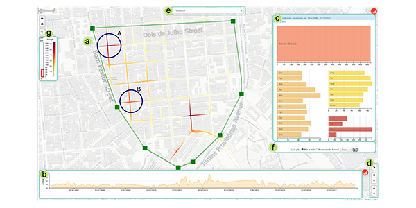
Visualization assisted crime analysis tools used by public security agencies are usually designed to explore large urban areas, relying on grid-based heatmaps to reveal spatial crime distribution in whole districts, regions, and neighborhoods. Therefore, those tools can hardly identify micro-scale patterns closely related to crime opportunity, whose understanding is fundamental to the planning of preventive actions. Enabling a combined analysis of spatial patterns and their evolution over time is another challenge faced by most crime analysis tools. In this paper, we present Mirante, a crime mapping visualization system that allows spatiotemporal analysis of crime patterns in a street-level scale. In contrast to conventional tools, Mirante builds upon street-level heatmaps and other visualization resources that enable spatial and temporal pattern analysis, uncovering fine-scale crime hotspots, seasonality, and dynamics over time. Mirante has been developed in close collaboration with domain experts, following rigid requirements as scalability and versatile to be implemented in large and medium-sized cities. We demonstrate the usefulness of Mirante throughout case studies run by domain experts using real data sets from cities with different characteristics. With the help of Mirante, the experts were capable of diagnosing how crime evolves in specific regions of the cities while still being able to raise hypotheses about why certain types of crime show up.
Materials
BibTeX
@inproceedings{2020-Mirante,
 title = {Mirante: A Visualization Tool for Analyzing Urban Crimes},
 author = {Germain García-Zanabria AND Erick Gomez-Nieto AND Jaqueline Silveira AND Jorge Poco AND Marcelo Batista Nery AND Sergio Adorno AND Luis Gustavo Nonato},
 booktitle = {Graphics, Patterns and Images (SIBGRAPI) },
 year = {2020},
 url = {http://www.visualdslab.com/papers/Mirante},
}